


Natuna, is one of the regencies in Riau Islands Province. Natuna is the most northern islands in the Strait of Karimata in the north, Natuna bordering Vietnam and Cambodia, while in the South, Natuna is bordered by South Sumatra and Jambi. To the west, bordering Natuna to Singapore, Malaysia. And eastern borders with East Malaysia and West Kalimantan.
 |
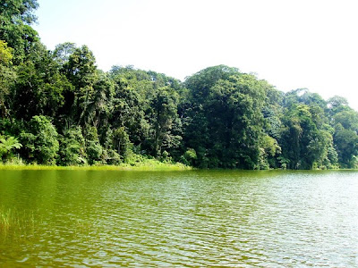
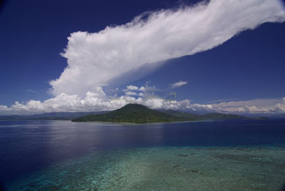
| Natuna Beach |
During this time, the Natuna residing on International cruise line is known as a producer of Oil and Gas. However, Natuna not only save the earth, because a lot of places can be used as local excursions, with the natural charm of beaches and the presence of marine parks is quite beautiful white sand coupled with the existing on some islands could certainly be used as a park., And the islands a beautiful place to visit.
Natuna has a lot of tremendous potential, this district has a panoramic view of unspoiled natural beauty. Cluster-cluster of islands, coral reefs, marine life, granite mountains, waterfalls. Very rich Natuna natural potential but I still minimal access and support facilities.
Tanjung Bira is a white sand beach which is quite popular in South Sulawesi. This beach including beach clean, neat, and clear sea water. The beauty and comfort of the beach is famous for up to foreign countries. Foreign tourists from many different countries who visited this place for a vacation.
 |
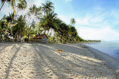
| Tanjung Bira beach |
Tanjung Bira beach is very beautiful and spectacular with white sand as soft as flour. At the site, visitors can swim, sunbathe, diving and snorkeling. The visitors also can watch the sunrise and sunset in a similar position, and can enjoy the beauty of the two islands in front of this beach, which is Liukang Island and Goat Island.
Tanjung Bira offers a somewhat different kind of dives than anywhere else in Indonesia. This type of underwater adventure full of challenges, with dive sites accompanied by fast-flowing type of white tip sharks and black tip which accompany divers around. Part of the point of diving here is recommended for experienced divers who love this type of diving that are at risk due to current conditions which are sometimes quite strong. However, there are also several dive points that can be easily accessed by novice divers. Bira is one place that you can easily interact passively with sharks where a place like this is very often in Indonesia.

Kakaban have an area 774.2 hectares and is located in Derawan Islands, District Derawan, Berau, East Kalimantan. Kakaban attract foreign tourists with some of its uniqueness, one of the lakes on the island of Lake Kakaban. Which, on the lake is filled by a mixture of rainwater and seepage of sea water from the pores of the soil and create a habitat for different endemic in most other regions of the world's lakes, besides Lake Kakaban there is another lake with brackish water that is in the Palau Islands, Micronesia.
 |
| Lake kakaban |
Lake Kakaban is sea water trapped in Kakaban, coupled with water from the soil and rain water. Lake Kakaban a prehistoric lake that is the time of transition Holosin. The extent of about 5 km ², walled cliffs as high as 50 meters, resulting in sea water is trapped no longer get out, into the lake. Administratively, Lake Kakaban including Berau Regency, East Kalimantan. In the world, a place like this is only found in Palau, Micronesian Islands in the South East Pacific Ocean. Thus Kakaban is the only island in Indonesia that have a lake in the middle.
Kakaban, one of the Islands Derawan nominated as a World Heritage Area. For those of you who loved nautical tourism, which has a vast region has a population of 774.2 hectares and the diversity of jellyfish that most in the world, four unique species of jellyfish that are not surrounded by high cliffs menyengat.Pulau this, beyond the cliffs west outspread 50-meter wide lowlands are composed of rock. From the plains of coral that you can be docked, of course, bathing suit and snorkeling equipment to swim toward land.
Waterfall Tour Gitgit located in the Village District Gitgit Sukasada Buleleng regency, Bali. Git-git waterfall is about 11 km from the city of Singaraja to the south toward the Village Pancasari and Bedugul.
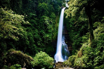 |
| Waterfall Gitgit |
Waterfall which has a height of about ± 35 meters is very beautiful and has a beautiful panorama and is in the cool temperate environment. Down by foot after passing the parking place Gitgit. Besides the sound pounding waterfalls and chirping birds, rice field, clove and coffee plantations as well as bamboo plants all the way to the waterfall presents a peaceful and natural atmosphere. Along the way, if you want to take a souvenir, can also buy knick-knacks are sold by local residents. Will certainly complete your natural holiday in Bali.
Waterfall located 300 meters above sea level has three major waterfalls. The highest reaching 60 meters, and is the highest waterfall in Bali.
To see the falls up close, visitors must go through a path made of cement. On the left side of the road there are some trees and vegetation are interspersed with a few shops. Rice fields and mountain scenery also be a bonus in itself.
Once the stepping foot into an uphill road, the scenery changed. On either side there are coffee, cloves and vanilla. In addition, although not specifically laid out, there are roses, hibiscus, lotus, hydrangeas, and marigolds.
The trail was formerly built by the Dutch to use residents who want to pass to the next village. Since opening to the public in 1975, this waterfall into one of the destinations for North Bali area.
Not far from this waterfall there is a place of prayer. Some steps forward have the marquee. We can relax while looking at the beauty of waterfalls, the grandeur of the Creator, and enjoy the silence of nature is accompanied by the faint sound of water that never disappear. From another direction we can see the sights of the shallow river crossing bridge is decorated high enough.
Place location Waterfall distance approximately 500 meters from the highway agency, the atmosphere is still so naturally will be very challenging for those of you who like trecking tour. Here will feel comfortable because it would be much sound the roar of noise, the atmosphere here is still retained its natural purpose. Along the road you will find plantations of clove, coffee, nutmeg, and cocoa.


