Background
Kawah Putih(White Crater) FestivalKawah Putih(White Crater) is a crater that is located at the summit of Mount Patuha a famous beauty of the white overlay the crater and slopes background panorama Mount Patuha very beautiful. In addition the location of Kawah Putih that is located at an altitude 2434 meters above sea level makes the air around the crater feel cool.

What would happen if the natural beauty of the Kawah Putih and slopes Patuha combined with cultural and artistic action Sunda than local artists? Watching a performance of art and culture amid the wild mountains of South Bandung will be presenting a different sensation. A sensation that will bring you into the atmosphere in the past.

Kawah Putih(White Crater) Festival ready to make hundreds of people spellbound. The event will take place much fun activities, such as cross-country race to art performances involving thousands participants. The event will take place on June 6 to 15 July 2012. There are an estimated 1,000 people are involved and come to see this festival.

Kawah Putih is an excellent tourist destination in Bandung, West Java. This place has a natural overlay the beautiful and charming scenery.

Kawah Putih(White Crater)Festival is an annual agenda in the area attractions in the mountains of Ciwidey, Bandung by displaying a variety of potential local cultural arts.

Kawah Putih(White Crater) Festival activities inserts a message to increase the many visits into tourist attractions that are unique to the Crater Lake are green and mixed with sulfur content.

Few main agenda than activities of the White Crater Festival is staging art and culture than Bandung and the dance displays that tells about the beginnings of the Kawah Putih and progress.

They will also be held indigenous spiritual ceremony at the Kawah Putih citizens as a form of thanksgiving to God.

White Crater Festival aims to preserve the culture as an integral in the tourism, exposing the nature and culture of West Java, are reminding the public to cure homesickness and pride of culture and its traditions. The festival is also expected to make the culture as part than media interpretation of potential tourists and tourism in educating the public as well as invites the public to conserve natural resources wisely.

Various competitions. Arts festival that will appear in most cultures including Buhun, such sisindiran, rhymes, tarawangsa, celempungan, seuseungitan and whistle. You can also enjoy the other attractions are also located in the Ciwidey tourist areas such as hot springs and beautiful panorama Situ Cileunca.

In this festival, there will be plenty of activities ranging from Pasanggiri Tembang Kawah Putih, Giri Wana Rally (cross-country race), wedding festivals, and performing arts. Certainly, visitors can enjoy panoramic views than nearby Kawah Putih.

This festival can fill your vacation time. There are natural charm and unique culture that you can see there.
Mamuya mountain is very famous for the public embarrassment, especially the northern mountain town of Tobelo is often climbed by the climbers and many interesting attractions that exist around mamuya mountain areas such as hot water Mamuya. Springs are sourced from the Mount Mamuya. Hot water is excellent for use in the bath. For the local community hot water mamuya believed efficacious cure various skin diseases.

Mamuya Mountain Areas
Mount Mamuya located in the village, district Galela, is only 15 km from the city Tobelo, North Halmahera Regency - North Maluku.

Do not think too much as this place is very easy to reach, only about 20 minutes drive from Tobelo. The location is also adjacent to each other. So if you have the opportunity to Tobelo and about 2-3 hours of free time the two sites are worth your visit on the agenda.

Hot Water Mamuya sourced directly from the Mount Mamuya. Located not so far from the main highway Mamuya Village. Still very natural bathing pool with crystal-clear water which surrounded the grove of trees. Although the local swimming baths have been used inter-generational flow of water but still produced a very well maintained.

Generally the tourists visiting this place in the afternoon until early evening. Recommended for you. Come early in the morning before 5 then you will get excellent water quality and bathing locations that are still very quiet. It's just that given the location of the baths Mamuya still less illumination so flashlights are mandatory equipment that must be taken.

Mamuya Mountain Areas
Mamuya bathing in the morning while accompanied by birds singing is fun.
The slopes of Mount Ungaran it saves a lot of sights that are not less interesting to the tourist attractions that have been and never counterparts during this visit, one of which is Village Medini, Boja District, Kendal District.


There are carpet of tea gardens, coffee fields, pine forests, waterfalls, tea walk paths, village-style homestay, and green tea processing factory. All that will greet us when he first set foot there.

Behind the ferocity of Mount Ungaran, Semarang, Central Java, stored panoramic beauty of nature is no less interesting to the tourist attractions on the other boards. Enjoy the tea gardens, sparkling waterfalls, and if you're lucky, a black eagle wings.

Medini, Promasam, Boja and Semarang, Central Java is the feel of the natural beauty of His creation is hidden behind Mount Ungaran ferocity.

Hidden Beauty on Slopes Mount UngaranCover the tea plant that surrounds the foot of Mount Ungaran sprawling in all directions. Eyes looked as if not exhausted the extent of the green tea plantations. An agro-tourism potential that should be a business opportunity in the field of nature tourism and agriculture. In some places like in Lembang, Peak area and some other places, tea plantations in governance has become a tourist packages are attractive and promising business fields. However, little regret potential of tea and coffee plantations in the slopes of Mount Ungaran, Picker seems to just enjoy the tea leaves in sheet for rupiah and nature activists who climbed the peak Ungaran bebes.

Natural atmosphere of the countryside is decorated tea leaf pickers babble and silence of nature is wrapped by a thin haze, will bring us into the realm of the imagination like no other.

The sound of gurgling waterfalls, and the aroma of tea blend naturally into the main treat in the village. Of course, this adds to our reluctance to leave immediately.

The mountain is very special that the heat of the earth on the south side and north side of the mountain, also in the mountains to the east. The highest heat was in Gedongsongo in the presence of steam and outdoor temperature 86°C are also hot springs. Just north of Mount Ungaran there are some hot springs with temperatures ranging from 48°C and 53°C. The hot water contained in the east of the mountains have warm temperatures ranging from 42°C.

Heat generated in this Gedungsongo associated with the youngest volcanic activity that occurred in GunungUngaran, that since the flow of lava in the crater andesive the north. There are no records of historical eruptions GunungUngaran. Several times the activity of the eruption had occurred in the middle of the mountain near the summit of Mount Ungaran, thus forming a volcano.

Natural pathways tea walk, jungle tracking, or jeep adventures to challenge our adrenalin. At night, dark and cold mountain ambush is the perfect time to light a campfire. We can enjoy the warm evening wedang with ginger, grilled sticky rice, and other fire-grilled menu.

A tourism potential that is very dear to the pass away. Maybe with a good arrangement and construction of support facilities that will either attract tourists to visit this site. For those who like adventure and ran cross country will be adorned with lines and beautiful scenery at Mount Ungaran.
Mount Tampomas with the power of natural phenomena is so beautiful, unique, mysterious and adventurous spirit to be able to tempt the adventurous to climb outdoors. Moreover, on the other side of Mount Tampomas always associate with those things or all kinds are a little bit smelly Magic.


Initially, the mountain was named Mount Gede, and previously named mountain Geulis. But people who mengkeramatkan Mount Indramayu they call it Mount Tampomas. Tompo receiving Gold = gold (in the form of heirloom weapons made ​​of metal called pendok Mas mas that are stored on top of the mountain with supernatural way that the mountain was not erupting).

"tos dido'akeun ku sepuh-sepuh kapungkur supados teu bitu deui" and what happens? it appears Cipanas Conggeang gas and water as waste heat from inside the belly of the mountain. Indeed, in the history of Mount it used to erupt and cause suffering people around the mountain. Even the capital of the kingdom also moved, to have capital in Tanjungsari The Sumedang town right now is made ​​in the Netherlands.

Mount Tampomas is not as famous as the other mountains in Indonesia especially in Java. Mystery Mountain Tampomas does not pick can be separated by the tomb and relics of the Sacred Site (former) King Siliwangi feet. On the Slopes Tampomas also found Stone pictorial, Fractions ARCA, Stone Fence, Small Pyramid, and the Statue of Ganesha is found by a team of researchers from the Foundation for Archaeological Sites. Padaringan is found on the eastern slopes of Mount Tampomas in the surrounding Ciputrawangi, Leuweung Temple, Peak Narimbang, Batu Lawang , Rice Kalapa, Peak Block Manik and Cibenteng.

Mattresses are said to be the stone bed Stone Padaringan King Siliwangi and supposedly in use or place where offerings deliberation. This proves that Tampomas Mountain area rich in natural beauty, cultural heritage and the history of keraja'an Pajajaran
Tampomas Mountain Nature Park in District Dua Buah, Congeang, Sindangkerta and Cibeureum Sumedang District. State of the field area of this Park is mountainous with altitude between 625-1684 meters above sea level.

Flora The vegetation of this region includes the type of mountain rain rain, flora made ​​up of diverse species of trees and woody-poonan species of lianas and epiphyt group. Flora that dominates the region are: Jamuju (Podocarpus imbricatus) Rasamala (Altingia excelsea) Saninten (Castanea argentea) Fauna wildlife that live in this area are: Mouse Deer (Tragullus javanicus) Monkey (Trachypithecus auratus) Boar (Sus vitatus) Several species of birds .


Attractiveness Object Some interesting attractions in the area of ​​Mount Tampomas namely: Peak of Mount Tampomas (Sangiang Taraje) With a height of ± 1684 meters above sea level, covering an area of ​​1 Ha is an open area. This location has a high aesthetic value because of this place, tourists can enjoy the beautiful natural scenery toward Sumedang and surrounding areas. The existence of craters craters and boulders big black adds richness to the viewer's imagination. The natural beauty of the flora and fauna that is still intact / original.

Nature tourism activities that can be done is: Enjoy the beautiful scenery and cool mountain climbing and cross country Photographing Camping Facilities Number of facilities and infrastructure is still very minimal.
Sangiang Island Nature Park is located in the Village Cikoneng, District Anyer, Serang regency, Banten province, Indonesia. Arc of natural attractions Sangiang remains enchanting island due to its natural condition is still beautiful, coral reefs and mangrove forests which extends along the coast of the island.


The air is cool and fresh, green and shady trees, as well as a wide ditingkahi by the chirp of birds, making the Island Nature Park Sangiang aptly chosen as an exciting place for recreation with family or colleagues.

In this area, there are a variety of rare flora, such as sea pine (Casuarina equisetifolia), dadap sea (erithrina variegata), bayur (Pterospermum javanicum), ketapang (Terminalia catappa), nyamplung (callopphyllum inoplhylum), fires (avicenia sp), sea ​​hibiscus (Hibiscus tiliaceus), walikukun (actinophora fragrans), and so forth.

A variety of rare fauna, such as the langur (trchyptus auratus), monkeys (Macaca fascicularis), jungle cat (felis bengelensis), porcupine (Hystrix bachura), Swallow (Collocalia vulvanorum), bluwok birds (ibis cinereus), egrets furious (egretta sacra) , egrets buffalo (ardeola speciosa), egrets iron (threskiornis aethopica), kestrel (elanus hypoleucus), and the python (python reticularis), is also easy to find in this region.
On the northwest side and the southern island of Sangiang, and along the coast and Mount Gede Bath Stone, a natural tourist area at once challenging and exciting. A broad region and supported by a variety of terrain contours, giving enough space for visitors to do various activities, such as cross country sports, mountain climbing, along the valley, biking, camping, shooting, and enjoy the panoramic beach and steep ramps.

For enthusiasts suba diving, snorkeling, sunbathing, fishing, boating, and see the beauty of coral reefs and marine parks with a glass bottom boat, it is recommended to visit the area of ​​Tanjung Raden, Legon Waru, and the southern ocean waters contained in Sangiang Island.

There, visitors can still see remnants of the second world war, such as cannons and the fortress from the advancing Japanese troops Allied soldiers.

Meanwhile, a variety of ecosystem wealth, such as coral reefs, mangroves (mangrove), and coastal forests, a fertile ground for research and development of natural sciences, as well as scientifically interesting sights.
In the area Sangiang Island Natural Park there are also many other facilities, such as tourist information centers, tourist guides, guardhouse, forest police, spacious camping ground and secure, guest house, rental equipment for diving, dock, and boat rentals and boat speed to around the island Sangiang.

Sangiang Island Nature Park, an area known as the Seven Wonders of Banten presents a travel package plus a pity to pass as a tourist destination or weekand. Because, in this tourist area but tourists can enjoy the natural beauty, historical tours are also available, and scientific tours. So, other than as an interesting tourist attractions, the area is also a regional education and research.

Mount Tambora is an active stratovolcano located on the island of Sumbawa, Indonesia. The mountain is located in the district of Dompu, West Nusa Tenggara Province. Tambora is formed by the subduction zone beneath. This increases up to 4300 m altitude Tambora which makes this mountain was once one of the highest peak in Indonesia and drying large magma chamber inside the mountain. It took centuries to refill the magma chamber.


This volcanic activity reached its peak in April 1815 when it erupted in the scale of seven on the Volcanic Explosivity Index. The eruption's largest eruption since the Lake Taupo eruption in the year 181.

This eruption came to the island of Sumatra (over 2,000 km). Volcanic ash falls in Kalimantan, Sulawesi, Java and the Moluccas. This eruption caused the death of up to no less than 71,000 people with 11,000 to 12,000 of whom were killed directly as a result of the eruption. Even some researchers estimate up to 92,000 people were killed, but this figure is questionable because based on estimates that are too high. Moreover, this eruption caused global climate change. The following year (1816) is often referred to as the Year Without a Summer because of the drastic change of weather North America and Europe due to dust generated from this Tambora eruption. As a result of drastic climate change is a lot of crop failure and livestock deaths in the Northern Hemisphere that caused the worst famine in the 19th century.

Geological Agency of the United States until the eruption of Tambora crowned as the most powerful volcanic eruptions in history. The eruption of Tambora even 10 times more powerful than the eruption of Krakatoa, and 10 thousand times greater than the eruption of Mount Eyjafjallajökull in Iceland last year the European air traffic mess.

During an archaeological excavation in 2004, a team of archaeologists found the remains were buried by the eruption of culture in 1815 at a depth of 3 meters in pyroclastic deposits. Artifacts were found in the same position when the eruption occurred in 1815. Because of the similar characteristics of this, these findings are often referred to as the "Pompeii of the east".

Soromandi is a new sub region Bima regency, West Nusa Tenggara, Indonesia.Kecamatan is located 20 km north of District of Bolo.


The word "Soromandi" comes from the word 'soromandu', which is the name of a mountain in the village of Sai district Soromandi. Soromandi community is predominantly Muslim, the majority of livelihood from farming because of the vast land, geography and weather are very friendly. Infrastructure such as roads are pretty good for two or four-wheeled vehicles. There are a variety of amazing natural wealth such as: original Honey, Wild Water horse milk, Lobster Aquaculture, Plants and animals are also diverse, and many others. Natural beauty is so beautiful, coastal cool and clean beaches, towering mountain Soromandu, the air is very fresh dikala greet dawn with no pollution whatsoever. There is also evidence relics of ancient history, and still many others.
Nglanggeran mountain situated in the village Nglanggeran, District Patuk Gunungkidul district of Yogyakarta city. With a height of between 200-700 masl. This region is a region with litologinya composed by old volcanic material and has a beautiful landscape and the geology is unique and of high scientific value. From the results of existing research and reference, is declared Mount Nglanggeran Ancient Volcano. We've often heard and seen pictures of human Purba, well as whether the Ancient Volcano?


Nglanggeran name comes from the word "planggaran 'meant any malicious behavior must be caught. Others have said the word "permanent" means a secure and peaceful village. In addition to such designation, the mountain is composed of many stones are known by the name of Mount Wayang because there is a mountain / rock that resembles a puppet characters. Punakawan the puppet characters, namely Semar, Gareng, Petruk, and Bagong.

Another belief says that Mount Nglanggeran as Mount Revelation because the mountain is believed to meditation as a means of obtaining revelation from God Almighty. Water from the mountain Nglanggeran often taken from the Sultan's Palace courtiers as a means to beg peace and safety of all people of Yogyakarta.

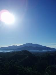
Mount Agung is the highest and most revered mountain in Bali. Although often covered by clouds and fog, but if a sunny day summit of the mountain can be seen from almost all places in the South and East Bali. Therefore, the mountain is visited by many climbers.

Regions in the South Mountain is between Rendang and Amlapura has a very impressive panoramic view through a variety of scenic rural roads decreased by tetatur go to the east of Bali. Rendang is an attractive small town, easily reached by public transport from Semarapura or from Bangli through a rather small way.

Much beauty in the tourist island of Bali's eastern tip. But not many local tourists who do not know. Besides Pura Agung Besakih and Candidasa, there are attractions Soekasada Taman Ujung, parks Tirtagangga, Amed and Tulamben beautiful beach, which has an exotic beauty at sunrise. Also with diversity under the sea biota, which can be enjoyed by snorkeling and diving.

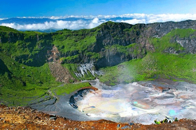
Gunung Agung is a strato volcano, the mountain has a very large craters and deep that sometimes - sometimes release fumes and water vapor. Of Pura Besakih seems spiky mountain is perfect, whereas the peak of this mountain elongated and ends in a circular craters and wide.


Many interesting attractions in the Natuna besides of course turned out to have a marine tourism Mountain Ranai fascinating and unique. Said to be unique because the mountain is commonly found species of rare and unusual trees grow in height standardnya plains.  

Ranai MountainRanai Mountain offers a variety tropical flowers and trees that grow around the mountain with color and captivating aroma of tropical forests. This mountain also has a gradation of types of plants that differ from lowland forests to upland forests. This type of forest as part its territory is often shrouded by fog, allowing certain types of vegetation can grow in the mountain region. Although this mountain is not classified as high, but because of its position in the middle of the sea wind blows strong, feels more than when climbing a mountain above 3,000 meters.
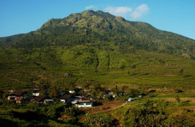
Lumbok located in the village, District Sukau, West Lampung regency. This mount attracted many tourists for its natural beauty, the air is fresh and natural.

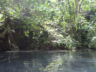
Mount Seminung now stands firmly on the shores of the lake is clear that present watery scenery was beautiful. At the foot of Mount Seminung there are natural hot springs that come out of the lake bottom. Around the lake can also be found Subik waterfall. Another interesting place to visit is the island Marisa is located not far from the hot water. 

Mount Seminung
the beauty of Mount Seminung
Not a few tourists who fell in love seeing the lives of those people that are still steeped in traditional culture, something very rare. You can enjoy the beautiful panorama of Lake Ranau, surrounded by the Bukit Barisan expanse of green carpet.

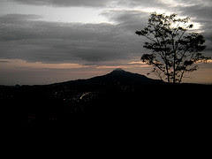
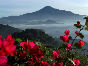
According to legend, the lake was created after a large earthquake and volcanic eruption of Mount Seminung is leaving the a large basin. Which previously flowed the great river at the foot of the volcano had then become the main source of water that fills the great basins.

All around the lake began overgrown with many plants, including shrub that locals call it Ranau. That is why the lake was named Lake Ranau.
Recognize Mount Seminung
Bantimurung Karst Mountains - South Sulawesi 
Identical to the known karst limestone, barren, hot, dry and craggy rocks tend to robustness white. Karst area Bantimurung Bulusaraung National Park has long been known as the limestone mountains that kept many potential range of distinctive and unique. These characteristics would have been able to invite a variety of disciplines and among the parties to maintain sustainability, manage and use for various purposes.

Bantimurung Karst Mountains
Bantimurung Karst Mountains - South Sulawesi

One area that many tourists are attracted Bantimurung Natural Park which is located in the Maros district of South Sulawesi Province. Having a beautiful natural potential, as a place of cultural tourism, and is a habitat for more than 84 species of butterfly, which was dubbed the Kingdom of Butterflies.

Bantimurung National Park has the most beautiful natural scenery. Because in this park, there are sources of water that never dry. So that various types of plants can survive in the long dry season.

Enchantment Natural Park Bantimurung as natural assets owned by the South Sulawesi Province, precisely Maros National Park Bantimurung Bulusaraung. Potentials that exist both tirta tourism, biodiversity and beauty of the cliffs karstnya as nature tourism with a special interest needs to be kept and maintained its existence. While the potential is presumably still hidden and have not been identified, need to be dug and carried peneltian further as the material development of the next tour.


Kawah Ijen is an acidic crater lake at the top of Mount Ijen, East Java. Kawah Ijen seen from the top of the mountain was amazing. The atmosphere is pleasant to feel both the landscape and natural ambience make nature lovers became interested in exploring this Ijen mountain as a recreation of the most beautiful. Lake is a large green with a bluish haze and smoke of the sulfur that is very charming. In addition, cold air with temperatures of 10 degrees Celsius, and even can reach temperatures of 2 degrees Celsius, will increase the sensation of a cold for which are not used to feel the air in Kawah Ijen. A variety of plants that exist only in the plateau can also be found, such as Flowers Edelweis and Pine Mountain.

Kawah Ijen
uniqueness of Kawah Ijen tour

Kawah Ijen is located at the top of Mount Ijen, which is one of a series of volcanoes in East Java such as Bromo, Semeru and Merapi. Mount Ijen is located east of Mount Merapi (in East Java, there is also a mountain that has the same name as the mountain in the Mount Merapi in Central Java). Kawah Ijen Tourism Regions or Nature Reserve Nature Trail is located in the subdistrict of Ijen, Glossy, Banyuwangi and District Klobang, Bondowoso.

At morning, when the sun began to shine Kawah Ijen region, beautiful scenery you can enjoy. Kawah Ijen is bluish green in color will be added to the golden sunlight bounces in the crater. Stunning scenery you can also get to witness the enchanting beauty of Mount Merapi, which is adjacent. Mount Merapi has similarities with the shape of Mount Ijen. The best time to witness the beauty of Ijen is in the morning.

There are mining sites that became another major uniqueness of Kawah Ijen tour in addition to panoramic beauty that was there. Place of extraction of sulfur contained in the bottom of the crater, parallel to the surface of the lake. Always dense white smoke gushed out through the iron pipe which is connected to the source of sulfur. From this bright red fumaroles melt melted out and exposed to ice cold air, forming a bright yellow solid sulfur. Rocks sulfur is to be taken.


One of the areas in western Indonesia were very engrossed. Bengkulu one of them. How not, this area was so beautiful with the natural landscape panning charm. Look if you do not believe it!

One of the places in which attention is Bengkulu Bukit Kaba, located in Kec.Curup Kab. Rejang Lebong, Bengkulu.

Bukit Kaba tourist attraction has a stunning natural charm. We can see the rows of the Bukit Barisan altitude 2000 m above sea level.


Bukit Kaba - Bengkulu
The beauty along Bukit Kaba
Natural Attractions Mount kaba is a twin volcano with a black mountain that has been extinguished. At its peak there were three craters are quite beautiful to be enjoyed. To reach the summit of this mountain climbers kaba first.

When the sun started shining, the sky represents the beauty of the Kaba as the city of Bengkulu. This is a real model of Bengkulu. Where is the beauty of nature can not lie. He was able to say through every inch scenery so spectacular.

The beauty of it would not disappear. Protrudes into the large crater, as if to prove the consistency of nature that remain in their habitat. The crater is so beautiful. Surrounded by green hills natural nan. Taken possession of cold air return. Due to the constant mist from the mouth of the crater.

Wonders of the Bukit Kaba seemed forever to be discussed. Nan this magnificent universe can be enjoyed when you visit Bengkulu.

Can not wait to see the natural splendor of this? Just come to Bengkulu, and enjoy its charm.


Mount Wilis is a non-active mountain located on the island of Java, East Java Province, Indonesia. Mount Wilis was originally named the mountain Pawinihan. Mount Wilis has a height of 2552 meters. The peak at the border between the six districts of Kediri, Tulungagung, Nganjuk, Madiun, Ponorogo, and Trenggalek. 

Mount Wilis - East Java
Mount Wilis also has a panoramic view of nature that is not less amazing for you who like the panorama of the falls, be prepared to awe. Imagine, several waterfalls with stunning panoramic view all around, can be found on the east side of Mount Wilis this.
Mount Kerinci is the highest volcano in Indonesia and is still in an active state. Located in two districts of Kerinci and Sulak Running. Foot of this mountain you can also find tea plantations located in the village of grit Tuo. Mount Kerinci is under the protection of Kerinci National Park Seblat. On this mountain forest areas we can still find the Sumatran tiger.

the highest volcano in Indonesia
The highest volcano in Indonesia
The view from the summit of Kerinci very intriguing, we could see the lake and lake Kerinci situjuh which is above the top of the hill situjuh, as well as in the southern part looks Lubuk Gadang and Muara harbor.


While in the west was the Indian Ocean. very beautiful. Mount Kerinci in Jambi city can be achieved through, or the city of Padang, or also from Muara Bungo. Muara Bungo Sumatra Cross is located on the road between the provinces of Jambi and West Sumatra.


Also on site Kerinci Seblat National Park there are also a community called "PEOPLE KERINCI", this community until now very difficult to find. French anthropology team is still investigating. According to locals, Kerinci has a tall posture of children aged 3 years and have long hair, they are unique from the soles of their feet upside down, not like we are behind the heel but the people of Kerinci is there in front of her heels and toes facing rearward . Their movements are very fast, fast sangking photograper from French investigators were not able to take pictures of them, despite being face to face.


Tourism Mount Kerinci - Jambi Province Kerinci District, one of the districts famous for its tourist attraction in the province Jambi.


Located on the border between Central Java and East Java, Mount Lawu has beautiful natural scenery. Many special interest tourists whoclimb it. The mountain is also often visited by the pilgrims as savinghistoric sacred objects.
Lawu, Mount Beautiful Full Story & History - East Java
In the mountain-altitude 3265 meters above sea level (masl) It was indeed save many historical relics such as the Majapahit kingdom,Candi Ceto, which is a relic Sukuh Temple "Raden Brawijaya".

Mount Lawu is a sacred mountain by the people around, especially people living at the foot of the mountain. Not surprisingly, in certain months such as the Javanese calendar month of the Shura, the mountain is crowded mainly visited by the pilgrims who came fromthe area around the foot of Mount Lawu.

Historic relics had become one of the witnesses of history thatour nation since ancient cultured therefore should be preservedbecause it gives more value to this mountain.

Beside rich with history and mystery of the kingdom of Majapahit, Mount Lawu also rich in various natural attractions such as natural tourist attraction with Waterfalls Grojogan Tawangmangu, Telaga Sarangan with beautiful lake that is so charming, CandiCeto and Candi Sukuh which is a temple made ​​by RadenBrawijaya, and no less interesting is a natural tourist climbing MountLawu.

From the summit of Mount Lawu we will be treated to a natural eventthat beautiful sunrise. When looking towards the West will be seen the peak of Mount Merapi, Merbabu. And if you look towards the East will see the beauty of the Peak of Mount Kelud, Butak, and Mount Wilis who form the charming nature paintings. If you want to climb to the summit of Mount Lawu should not be too busy on Mondays to Fridays.

Some bird species can be found in the area of Mount Lawu, Birdsepcrti Anis, Perjak, Glass Eyes, and Bird's crust. It plant include Pine Mountain, Flowers Eidelweiss, Cantigi, rubber treeforest, Banyan, Rustania, and Puspa. Flowers Eidelweiss thrivesmainly in the valley and the slopes of Mount Lawu.


South Bukit Barisan National Park is representative of the Bukit Barisan mountain range consisting of vegetation types of mangrove forest, beach forest, tropical forest pamah up to the mountains in Sumatra.

South Bukit Barisan National Park

South Bukit Barisan National Park stretches from north of Bengkulu province, following the back of the Bukit Barisan mountain range extends to the south, to the Cape of China-Carambola on the southern tip of Lampung province.

Change and development of a National Park Wildlife Sanctuary is nothing but the manifestation of conservation efforts to protect and conserve natural resources contained therein. South Bukit Barisan National Park presents a challenge to the visitors to enjoy the wealth and natural beauty.

Because of the influence of the Bukit Barisan Mountains, this park is divided into two distinct areas, where half of the eastern semi-arid region. However, the relatively high rainfall throughout the year across the region.

South Bukit Barisan National Park - Lampung

Regions South Bukit Barisan National Park backed the southern tip of the Bukit Barisan Mountains, which has a fairly rugged topography. Quite steep eastern slopes, while the western slopes, towards the Indonesian Ocean, slightly sloping. The highest peak of this national park is Mount Pulung (1964 m asl) located on the west side of Lake Ranau. In addition, there are still many other mountains, namely: G. Sekincau, G. Balirang, and Bukit Pandan Bukit Gedang.


mountain jayawijaya

Do not be surprised if the top mountain climbers always world-class racing to climb one point of entry in the top seven rows of the continent. Especially with the existence of eternal snow which always enveloped peak.

But who would have thought if the snowy peaks that formerly was part of a very deep ocean floor! Guinea began to take shape at 60 million years ago. At that time, the island is still in the seabed sediments formed by stones. Precipitation intensive originating from the continent of Australia in a long period of time generate new land that is now called Papua.

Raja Ampat

Raja Ampat in West Papua's secluded location. This area stores a million beauty beneath the sea. Raja Ampat Marine tourism is recognized as one of the 10 best dive tourism in the world. Enchantment under the sea and natural wealth, the mainstay of the Raja Ampat regency through competitive world of tourism in Indonesia and the world. This area is known as a center for tropical natural resources of the world's richest. Raja Ampat's marine tourism potential and opportunities have become a major world stage

Primitive life

Another tourist attraction in eastern parts of Indonesia's most primitive life it is. There one can find people who are still living through.

Natural beauty

Snow in the mountains and natural conditions are still very nature is a very exotic landscape.

Lorentz National Park

is representative of the complete ecosystem for biodiversity in Southeast Asia and the Pacific. This area is also one among the three regions of the world that have a glacier in the tropics. Stretching from the snow-covered mountain peak (5030 meters above sea level), to stretch out to the coastal waters with mangrove forests and borders the Arafura Sea. In this stretch, there is a spectrum of ecological stunning alpine vegetation of the region, sub-alpine, montane, sub-montane, lowland, and wetlands.

Besides having a very high biodiversity, there are also some specific and unique presence in the Puncak Jaya glaciers and rivers that disappear a few kilometers into the ground in the Valley Balliem.